Four scientists analyzed the article and estimate its overall scientific credibility to be 'very high'. more about the credibility rating
A majority of reviewers tagged the article as: Accurate, Sound reasoning.

SCIENTISTS’ FEEDBACK
SUMMARY
This article at CNN reports on a new study that calculates the acceleration of sea level rise that has become apparent in the record of satellite measurements, which began in 1993. Because the satellite record is so short, this acceleration has not been clear until recently.

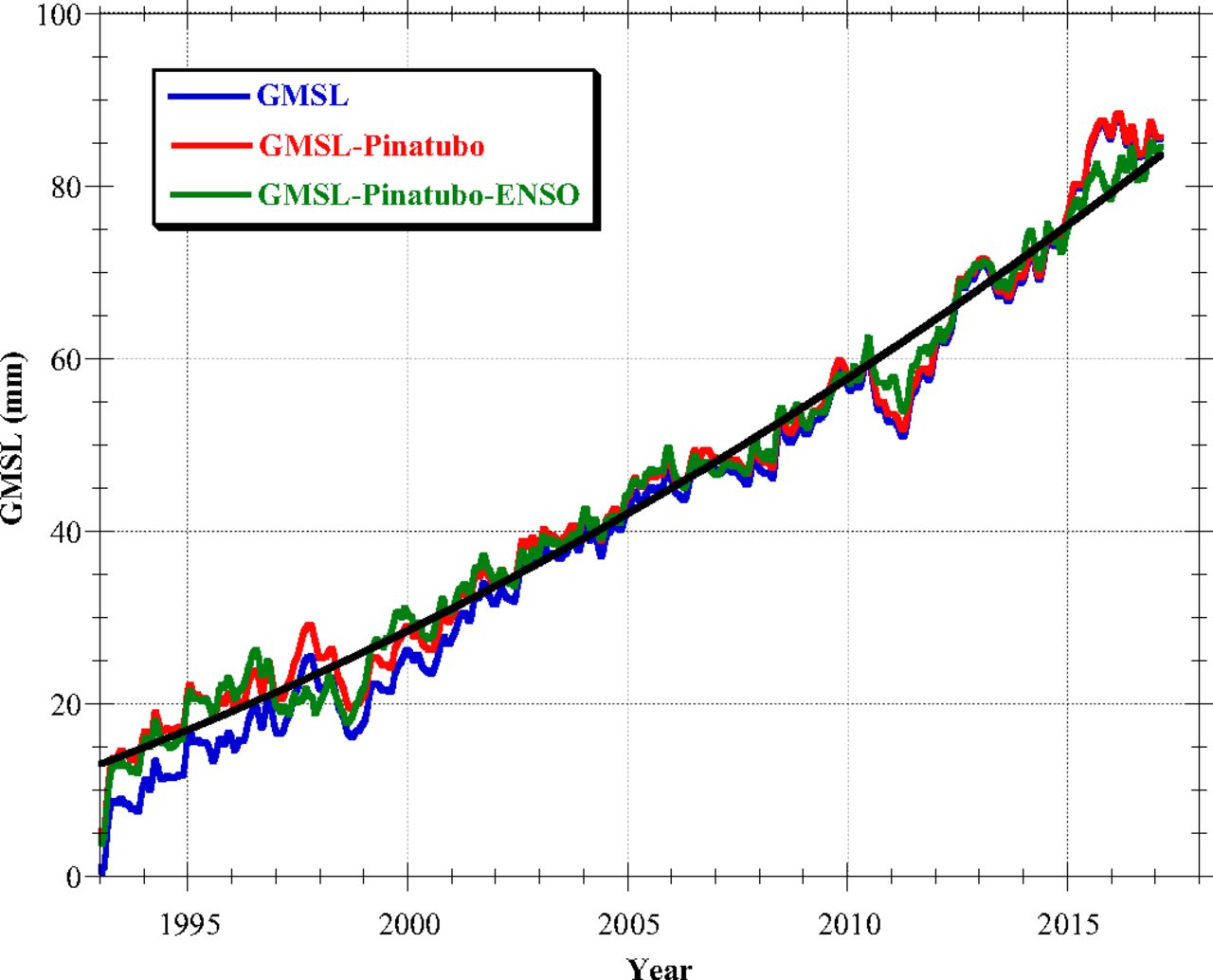
Figure – Global mean sea level (blue), after removing an estimate for the impacts of the eruption of Mount Pinatubo (red), and after also removing the influence of El Niño (green), fit with a quadratic (black). The acceleration is 0.084 mm/y2. From Nerem et al. (2018)
Scientists who reviewed the article found that it described the study accurately. The article could have clarified for context that many studies have analyzed sea level rise trends in tide gauge data going back to the early 20th century.
See all the scientists’ annotations in context
REVIEWERS’ OVERALL FEEDBACK
These comments are the overall opinion of scientists on the article, they are substantiated by their knowledge in the field and by the content of the analysis in the annotations on the article.
Keven Roy, Research Fellow, Nanyang Technological University:
This is, in general, a good article that represents quite well the message from the study under discussion, with only a few statements that could have been clarified.
However, I think that the article would have gained from placing the study in a better context, as there have been other data-based assessments of 21st century sea level rise1,2 (process-based or statistical). A comparison to assessments of modern sea level rise that included tide gauge data3 would have been useful too.
- 1-Jackson and Jevrejeva (2016) A probabilistic approach to 21st century regional sea-level projections using RCP and High-end scenarios, Global and Planetary Change
- 2-Kopp et al (2017) Evolving Understanding of Antarctic Ice-Sheet Physics and Ambiguity in Probabilistic Sea-Level Projections, Earth’s Future
- 3-Hay et al (2015) Probabilistic reanalysis of twentieth-century sea-level rise, Nature
Ernst Schrama, Associate Professor, Delft University of Technology:
I think this article accurately presents what we see in the satellite and tide gauge data. The wording “the projection agrees perfectly with climate models” is maybe somewhat strong. One could say the observation data is consistent with climate models.
Benjamin Horton, Professor, Earth Observatory of Singapore:
Global geological sea-level data from the Common Era (last 2000 years), global sea-level data from tide gauge records since 1880 and now satellite sea-level data from 1993 all show that the rate of sea level rise is accelerating. These accelerations in sea level is a cause for great concern.
Notes:
[1] See the rating guidelines used for article evaluations.
[2] Each evaluation is independent. Scientists’ comments are all published at the same time.
ANNOTATIONS
The statements quoted below are from the article; comments and replies are from the reviewers.
“Using satellite data rather than tide-gauge data that is normally used to measure sea levels allows for more precise estimates of global sea level, since it provides measurements of the open ocean.”
Keven Roy, Research Fellow, Nanyang Technological University:
This may be a bit of a misrepresentation, as precision is only one part of the story here. The length of the available records is also crucial—hence the need for studies of tide gauge data.
Benjamin Horton, Professor, Earth Observatory of Singapore:
Global geological sea-level data from the Common Era (last 2000 years), global sea-level data from tide gauge records since 1880 and now satellite sea-level data from 1993 all show that the rate of sea level rise is accelerating. These accelerations in sea level is a cause for great concern. As the satellite altimetry record length grows so does the satellite derived time series of (near) global mean sea surface height. Putting recent estimates of GMSL, 2.6-3.2 mm/yr, into historical context is an important and daunting task, and is necessary in order to quantify sea-level accelerations, both regionally and globally. This CNN article highlights the importance of Nerem’s excellent paper.
“Sea level rise of 65 centimeters, or roughly 2 feet would cause significant problems for coastal cities around the world.”
Keven Roy, Research Fellow, Nanyang Technological University:
It should be mentioned that this is a global average. The increase will not be uniform—exacerbating the consequences described below.
Benjamin Horton, Professor, Earth Observatory of Singapore:
But there is one caveat that I would like to bring up, whether sea level showed an acceleration or not in the satellite era is of less importance compared to the rates of rise we will have to endure in the remainder of the 21st century (and beyond). Predictions of future sea level rise should be based on physics, not statistics. Statistics simply doesn’t enable us to foresee the future beyond a very brief window of time. Even given the observed acceleration in the satellite era, the forecasts we should attend to are not from statistics but from physics.
“Therefore, scientists now have observed evidence validating climate model projections”
Keven Roy, Research Fellow, Nanyang Technological University:
I think this is a strong statement. The authors are not validating model predictions against observations—they are comparing model predictions to an extrapolation obtained from 25 years of data.
“Theirs is a troubling finding when considering the recent rapid ice loss in the ice sheets. ‘Sixty-five centimeters is probably on the low end for 2100,’ Nerem said, ‘since it assumes the rate and acceleration we have seen over the last 25 years continues for the next 82 years.’”
Keven Roy, Research Fellow, Nanyang Technological University:
This is an important point, and it is good to see it mentioned in the article.

